 Live Radio
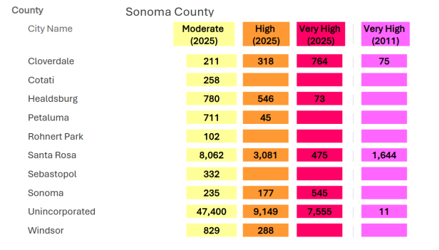 photo credit: Cal Fire
New fire hazard severity zone acreage totals for unincorporated
Sonoma County, and the county's nine incorporated communities.
The latest fire hazard maps for Sonoma County are out, and now local leaders want to hear from residents about the update.
The fire hazard maps aren't necessarily what insurance companies use for decisions about homeowners insurance, but Sonoma County Fire Marshal Steve Mosiurchak said that doesn't mean the maps aren't useful.
"Ultimately, what does it mean? It's letting the public know that they're living in areas of fire severity," Mosiurchak said. "It's a very scientific model that provides some accurate details of topography, fuel, weather conditions, past fire history."
The primary purpose of the fire hazard severity maps is for planning and policy making.
That means rules around things like building materials, defensible space, water supply, road width, and natural hazard disclosures in real estate transactions are required; depending on the fire hazard severity zone of a given property.
"Just a little extra scrutiny in code development and code application," Mosiurchak said. "Fire districts do have the authority to upgrade areas of moderate and high [fire severity], if they choose, they cannot downgrade. So you can't make it anything less [stringent] than was proposed by Cal Fire, but you definitely can increase it if they chose to do so."
Mosiurchak noted there is higher fire safety standards for areas in the "very high severity" category.
He said the hazard maps are also incorporated into wildfire protection and preparedness efforts like Community Wildfire Protection Plans.
Mosiurchak said at the county level at the moment, "they're required to adopt these maps within 120 days from the day that they are published for the public."
"So that puts us about June that they have to be adopted," Mosiurchak said. "Fire districts in the county [are] responsible for notifying...the public, which we're doing right now."
State regulators are currently working on updates to wild land-urban interface and building codes.
Most notable is a long-discussed "Zone 0". A zero-to-five-foot "no combustion" area around homes within Cal Fire jurisdiction, and homes within the very high fire hazard severity zones that are within the jurisdiction of local fire departments.
Those regulations are likely to be adopted by the end of 2025.
