 Live Radio
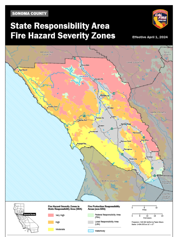 photo credit: Cal Fire
Cal Fire released new wildfire hazard maps for Sonoma County, the North Coast, and the Bay Area in a February 24th update to the Golden State's Fire Hazard Severity Zone (FHSV) maps.
It's part of a statewide phased roll out of new fire hazard maps, following an early February executive order from Governor Gavin Newsom.
They give a more detailed picture of fire hazard, including new 'moderate' and 'high' hazard areas, in addition to the 'very high' fire hazard designation.
The updated maps draw on new weather data and inputs like fire rotation info - when an area has burned previously - for areas where Cal Fire or local fire departments are responsible for firefighting, as well as enforcing fire-safe building standards.
The updated maps add 1.4 million acres across California into 'high' and 'very high' fire zones according to the Governor's office.
Cal Fire's Jim McDougald explained the concept of fire hazard.
"Hazard is what the landscape is based off fire probability, fire intensity, slope, weather," McDougald said. "Those factors come together along with vegetation to say that there's this amount of hazard on the landscape."
The updated maps increase the acreage of 'very high' fire hazard severity areas around Cloverdale, and in unincorporated Sonoma County, which now has over 7,500 acres in the 'very high' zone.
But the new maps decrease the acreage in 'very high' severity zones in Santa Rosa when compared to the 2011 maps; down from over 1,600 acres to just 475 now, covering areas like around the county's Los Guillicos campus, and south of Spring Lake.
Much of Santa Rosa is still designated as a 'moderate' or 'high' fire severity zone.
Each city in Sonoma County has at least 100 acres in a moderate severity zone.
McDougald said fire hazard is different than risk.
"So it doesn't measure like risk does," McDougald said. "It doesn't measure the impact that that hazard has on something. So let's say you have a house, we don't measure the impact that the hazard is going to have on the house."
What the updated fire hazard severity maps are useful for, McDougald said, is helping guide planning decisions and regulations, like home hardening rules and wildland urban interface building codes.
"So it's really about building home safety and community safety during construction...maintaining your defensible space," McDougald said. "The fire hazards severity zones are all really related to the mitigations required to build safer homes in areas that have wildfire hazard."
The maps won't be used for insurance decisions, at least according to the California Department of Insurance.
New rules introduced in 2022 require insurers to factor in mitigation efforts like home hardening, which McDougald said are not captured as part of the new Cal Fire hazard maps.
"Insurance companies look at risk because they're looking at what impact that fire is going to have on a structure," McDougald said. "So that's what they are modeling and basing their things off of. We're just doing it so we know what mitigations need to be put in place for that new construction. So that's why they're vastly different because one of them is truly risk, which is insurance modeling, and ours is hazard modeling."
State Insurance Commissioner Ricardo Lara's office noted that a change in hazard severity zone isn't likely to affect a single home owner's insurance, but his office also said insurance companies base their decisions on their own alternative risk maps and models.
Comprehensive new fire safe regulations for homes in 'very high' hazard zones, like maintaining defensible space and using fire resistant materials, which get factored into insurance risk, are being developed by California's Board of Forestry.
The Board of Forestry is also reviewing state and local responsibility area boundaries.
