 Live Radio
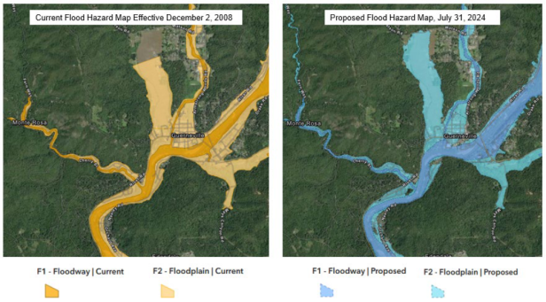 photo credit: Permit Sonoma
Current and proposed FEMA flood hazard maps for the Guerneville area of the lower
Russian Roiver in Sonoma County.
Flood zones along the Russian River just got bigger, on paper at least.
Sonoma County supervisors have accepted new flood risk maps from FEMA, the Federal Emergency Management Agency, for the Russian River watershed.
They are the first new maps in 30 years.
When voting on the maps, District 5 Supervisor Lynda Hopkins, who represents the lower Russian River said, "I do believe that this needs to pass."
"It has passed with the support of my colleagues," Hopkins said. "But I just do want to register the protest of whether it's, you know, appropriate for us to take actions that negatively impact property owners."
Hopkins cast a symbolic 'no' vote on adopting the updated maps.
The county needed to accept FEMA's latest flood risk assessment or get the boot from the National Flood Insurance Program, but the new maps are a bit of a catch-22.
They're needed to secure insurance on homes and commercial buildings, but structures within floodways and the larger hundred year floodplain are heavily regulated, or even outright banned from rebuilding if damaged in a flood.
That is the reason behind Hopkin's partial dissent Tuesday morning, and the same reason why Permit Sonoma's Scott Orr said the time's come to re-evaluate county rules.
"It's not often that we're talking about regulations that were enacted in the 1940's," Orr said. "We didn't even have a building code back then, so it's time for us to go and reassess; are those still meeting the needs for us today?"
Orr also noted Sonoma County rules about development within the floodway, the lowest lying areas most vulnerable to flooding, are more strict than FEMA's, at least for the time being.
"Through the fires you know, we made a number of changes to make it easier for people to rebuild," Orr said. "From a flood standpoint, you know, we want to make it clear that...we do want to support people rebuilding what they had in the event that there's a disaster."
FEMA's new assessment reaches far beyond the Russian River banks though; southern Santa Rosa resident Ed Clites, said homeowners like him in the Laguna de Santa Rosa watershed have been caught off guard by the new risk assessment as well.
"I just want you to know that I became aware as a 33 year owner of my home three years ago, that FEMA had declared my neighborhood to be a flood zone," Clites told the supervisors. "I wasn't notified by FEMA, I was not notified by the County, I was notified by my mortgage company who said, 'you have 30 days to get insurance, or we're going to get it for you,'" Clites said.
Rule changes floated for flood risk areas include a critical services overlay, which would allow essential community infrastructure like grocery stores to be rebuilt if damaged by a flood.
FEMA's new maps have put part of the Guerneville Safeway, the areas primary grocery, within the highest flood risk zone.
