 Live Radio
 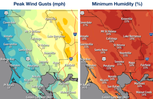 photo credit: NWSHeads up for incoming dangerous fire weather.
A Red Flag Warning will now be in effect starting as early as Saturday morning continuing through Sunday evening.
Forecasters with the National Weather Service say Saturday night through early Sunday will be the most critical time period.
Particularly for high elevation areas of the North Bay, where wind gusts will range from 45 mph to upwards of 50 mph.
That combination of gusty offshore winds and low humidity will affect large parts of the region.
Today the weather service said due to those expected high winds, forecasters have ALSO put up a Wind Advisory this weekend for the North Bay interior mountains and Marin Coastal Range.
Minimum relative humidity is expected to dip to as low as 10 percent, with overnight recoveries of 25 to 45 percent for the North Bay, East Bay and the Santa Cruz Mountains on Saturday and Sunday, adding to the elevated fire risk in these areas, forecasters said, adding to the elevated fire risk in these areas.
Meanwhile, the weather service also put up a Frost Advisory for the North Bay valleys late tonight into Saturday morning. Covering sensitive plants is advised.
Forecasters say moderate to major fire risk levels across much of the region will ease significantly starting on Monday.
